Finding historical satellite images is surprisingly straightforward once you know where to look. The hard part is knowing where to start.
Depending on what you’re after, “historical” can mean last year’s Sentinel-2 imagery, 1970s Landsat captures, or CORONA film frames from 1960. This guide focuses on the older end of that spectrum. Declassified spy satellite imagery, Cold War era reconnaissance photos, and archives that go back further than Google Earth’s historical layer.
I’ve spent years working with this imagery and have put together what I think are the most useful sources, starting with my own.
SpaceFromSpace Declassified Archive
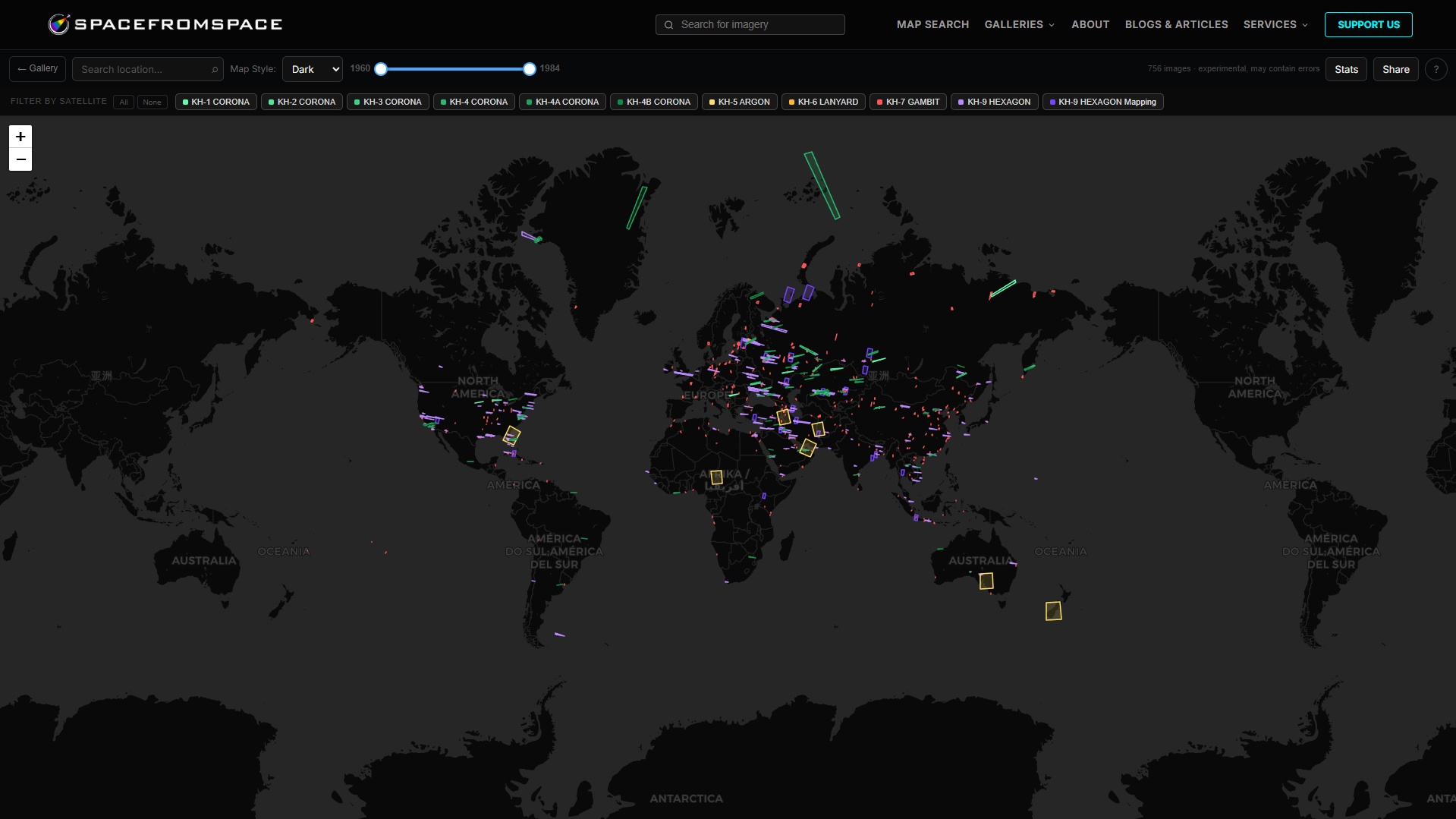
If you want declassified Cold War spy satellite images without having to navigate the USGS catalogue system, this is the place to start. SpaceFromSpace is my own project. A curated archive of 800+ (as of June 2026) georeferenced scenes from the CORONA, GAMBIT, and HEXAGON reconnaissance satellite programs, all free to browse.
Every image has been individually processed, georeferenced to its real world location, and made available at full resolution through an easy to use interactive map. You can filter by satellite program, zoom to a specific region, and compare the historical imagery directly against the modern basemap to see what’s changed.
The archive covers locations across every continent. Soviet missile sites, Cold War airfields, nuclear test facilities, shipping ports, launch complexes, cities, and more. You can even request images of a specific location to be added to the processing queue!
No account required. Everything is free.
USGS EarthExplorer
USGS EarthExplorer is the raw source for what’s in the SpaceFromSpace archive. If you want to download original CORONA, GAMBIT, or HEXAGON imagery yourself or explore parts of the archive that haven’t been curated yet, this is where to go.
The declassified imagery sits under the Declassified Data section in the dataset browser. You can search by location, date range, and program. Most of the available scenes can be downloaded for free. Some frames that haven’t been digitised yet can be requested for scanning, which costs $30 USD per image.
The interface takes some getting used to and the download sizes are very large. It’s not the most intuitive thing in the world for everyone, but once you’re familiar with it the depth of the archive is genuinely remarkable. Various aerial and Landsat imagery is also here.
CORONA Atlas (CAST)
The CORONA Atlas is a project from the Center for Advanced Spatial Technologies at the University of Arkansas. It provides a searchable, map-based interface specifically for CORONA imagery. This makes it a much friendlier entry point than other systems for anyone who just wants to find CORONA frames of a specific location without learning the wider USGS system.
Coverage is focused on the Middle East, Central Asia, and surrounding regions, which happens to be where CORONA imagery is most heavily used for archaeological and historical research. If you’re looking at sites in those areas, CAST is often the fastest way to find and preview relevant frames.
The imagery is linked back to the USGS holdings, so once you’ve found what you want you can go and download the full resolution file through EarthExplorer. Think of it as a more specialised search interface sitting on top of the same underlying archive.
Google Earth (Historical Imagery)
Google Earth is free and has a historical imagery search that’s worth knowing about. The depth of coverage varies dramatically depending on where you’re looking. Major cities often have imagery going back to the late 1970s or earlier, sometimes from aerial rather than satellite sources.
To access it, open the toolbar and look for the icon labelled Show Historical Imagery. A slider lets you step through available captures for your location. For some areas, it’s sparse. For others, it’s surprisingly rich.
Just Google It (Seriously)
It’s worth trying a simple Google (or your preferred search engine) search for the specific area you’re interested in. A lot of people skip this step and end up doing unnecessary work.
Many cities, counties, states, and regional governments publish their own historical aerial and satellite imagery archives, which often going back decades, and make them freely available online. These can be easier to access than other sources and higher resolution than anything in a global archive, because they were captured specifically for local planning, surveying, or emergency management purposes.
Try searching for things like:
- [city or region name] historical aerial imagery
- [state or country] government imagery archive
- [council or county name] GIS portal historic imagery In Australia, most state governments offer free historical aerial imagery through their land and spatial information portals. In the US, many state GIS offices and county assessors maintain archives going back to the 1970s or earlier. It’s somewhat similar for other countries.
University geography departments are another underused source. Several have digitised and published regional aerial photography archives that simply don’t appear in global databases.
The coverage is patchy, some regions have almost nothing, others have more than you’d expect, but it takes about 30 seconds to find out. If something exists for your area, it’ll usually show up in the first page of results.
A Note on the Declassified Programs
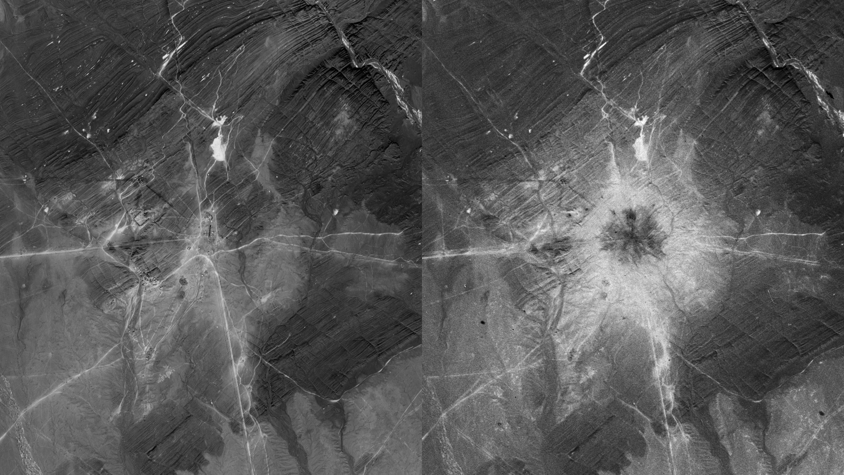
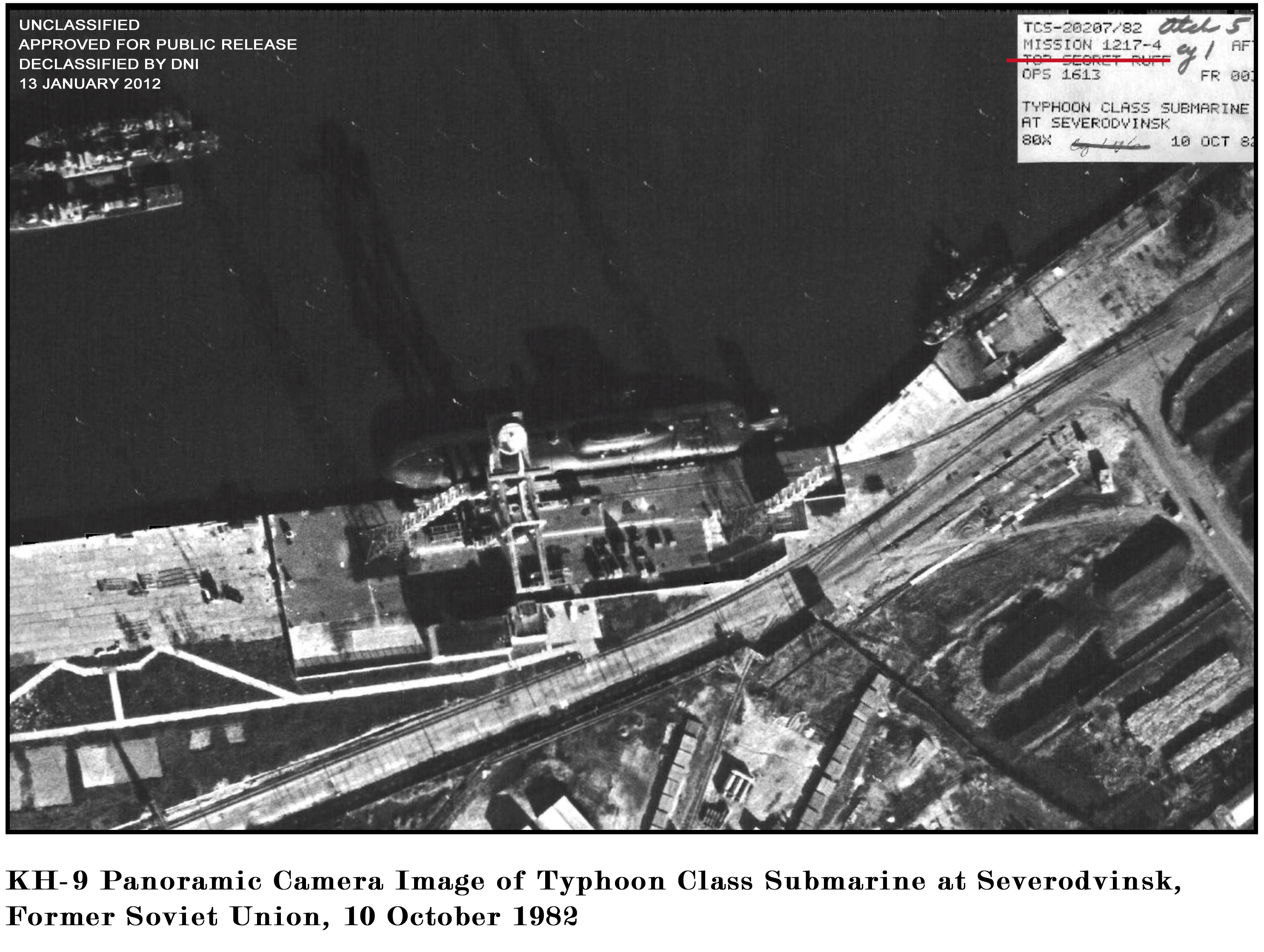
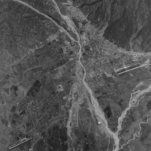
Most of the truly old satellite imagery, anything from before the early 1970s, comes from the classified reconnaissance programs run by the CIA and U.S. Air Force. CORONA was the first, running from 1960 to 1972. GAMBIT followed, with higher resolution. HEXAGON ran until 1984.
All three programs were largely declassified in stages from the mid-1990s onwards. The imagery is held by USGS on behalf of the U.S. government and is freely available to anyone. The challenge has always been accessing it in a usable form. Raw CORONA frames are large, ungeoreferenced scan files that require significant processing before they’re useful.
That’s what the SpaceFromSpace archive is built to solve. If you want to explore Cold War spy satellite imagery without building your own processing pipeline, it’s the fastest way in.