Every major nuclear test site on Earth was photographed from space. Most of that imagery has been public for decades, but not in the easiest to access manner.
Between 1960 and the early 1970s, the United States operated a series of classified reconnaissance satellite programs, CORONA, GAMBIT, and later HEXAGON, that systematically photographed the Soviet Union, China, and other hard or impossible to reach areas. Nuclear test sites were among the highest-priority targets. Analysts in Washington needed to know what was being built, what was being tested, and when. While communication interceptions and ground sensors could provide more immediate information, optical spy satellites could provide a visual overview of what was unfolding, mkaing it easier for most people to understand.
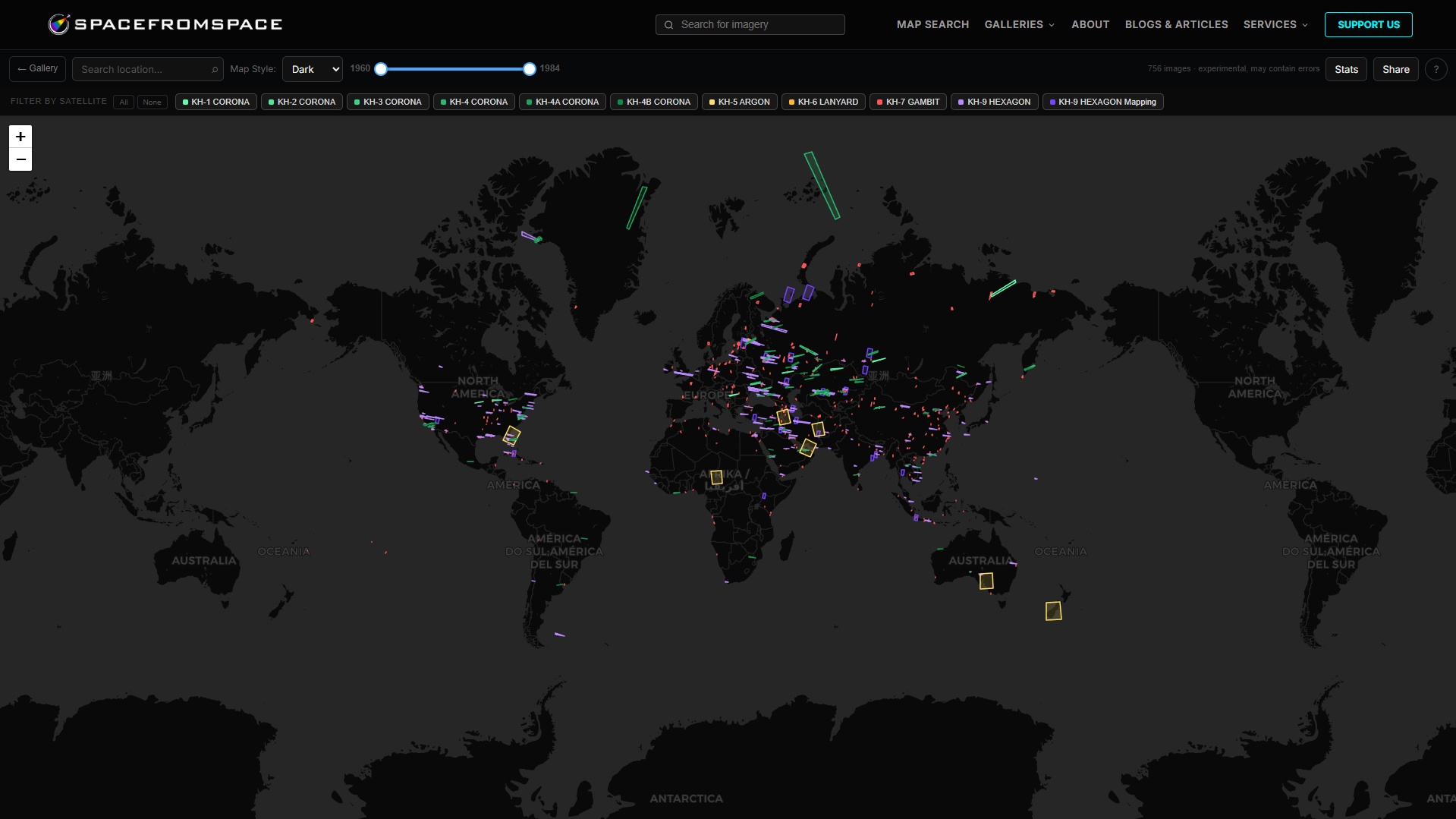
The imagery those satellites produced is now in the SpaceFromSpace declassified archive via the USGS EarthExplorer platform. Keep reading for an overview of some of those sites and what those satellites saw.
The Satellites
CORONA flew from August 1960 to May 1972, with more than 100 spacecraft and returning over 800,000 frames of film. [1] The program encompassed several camera variants, KH-1 through KH-4B, with later variants achieving ground resolution of around 180 centimeters (6 feet). CORONA imagery was declassified in February 1995 under an Executive Order signed by President Clinton. [2]
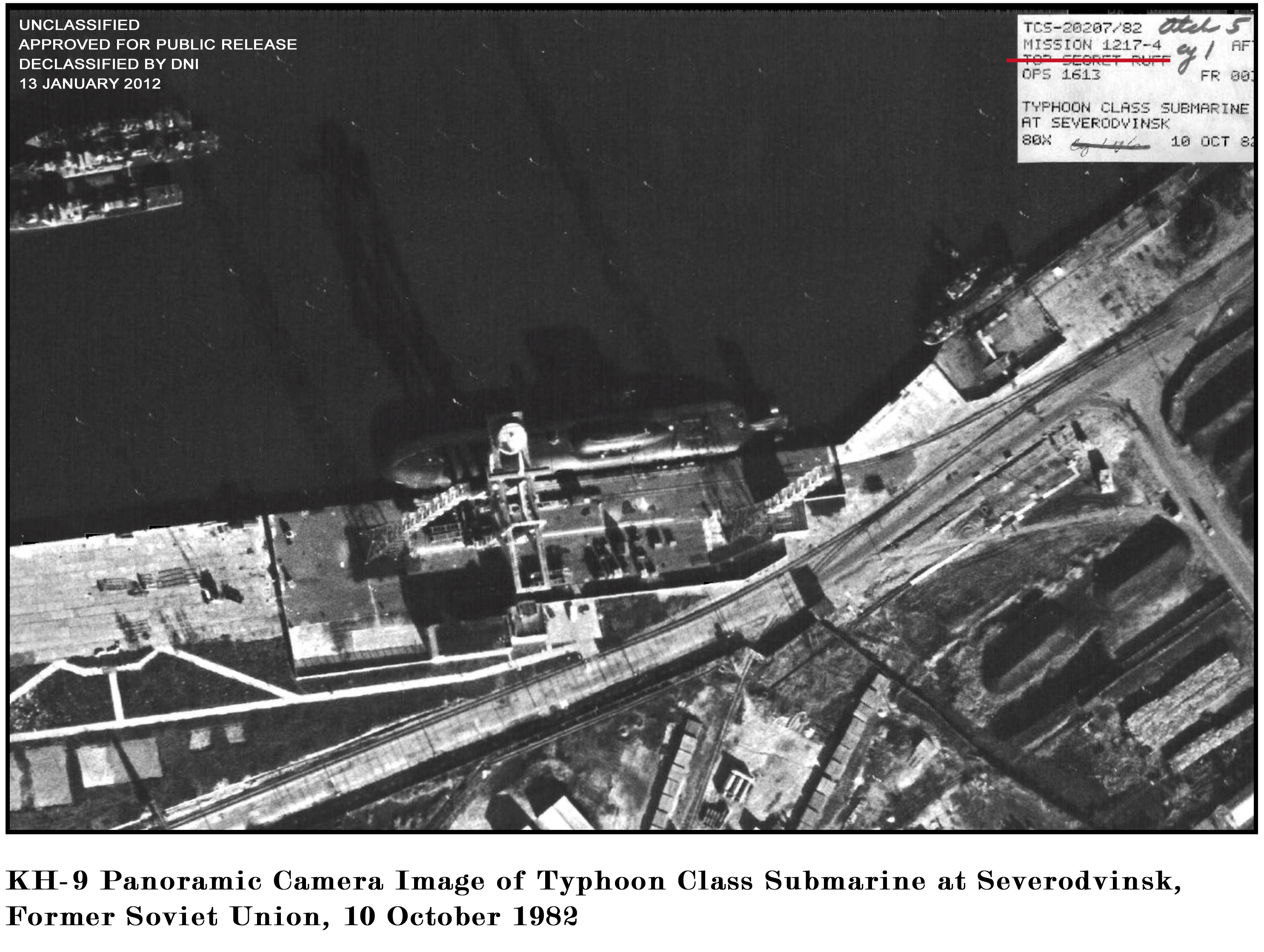
KH-7 GAMBIT operated from July 1963 to June 1967. It was a higher resolution system, designed to image specific high-priority targets at fine detail. Its typical ground resolution was 60 to 90 centimeters (2 to 3 feet). A large portion of the KH-7’s photography is of Chinese and Soviet installations. The imagery was declassified in 2002, however approximately 100 frames covering Israeli facilities remain classified. [3]
. By 040314-O-9999R-001.jpg from Air Force Link - PhotosTransferred from de.wikipedia to Commons by Avron using CommonsHelper., Public Domain, https://commons.wikimedia.org/w/index.php?curid=5094751")
Both of these systems returned film physically. Capsules were ejected by the satellite in orbit and recovered in mid-air over the Pacific by specially equipped aircraft before eventually making their way back to Washington D.C. for analysts to dig in to.
Before either program, U-2 spy planes had been conducting overflights of Soviet nuclear sites since at least 1956. [4] Satellites made the surveillance systematic.
Lop Nur, China
Location: Northwest China
Total tests (until 1996): 45
China’s Lop Nur Nuclear Weapons Test Base, sits roughly 1,500 kilometres west of Beijing. The Soviet Union helped select the site in the late 1950s, and construction of the base began around 1959. [5]
The U.S. reconnaissance satellites were watching well before the first test took place.
")
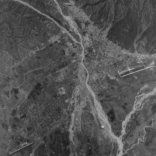
The earliest Lop Nur frame in the archive is dated December 12, 1961, captured by a KH-3 CORONA satellite. At KH-3 resolution, the image shows road networks and early infrastructure, the shape of a facility being built, not yet one that had been used.
")
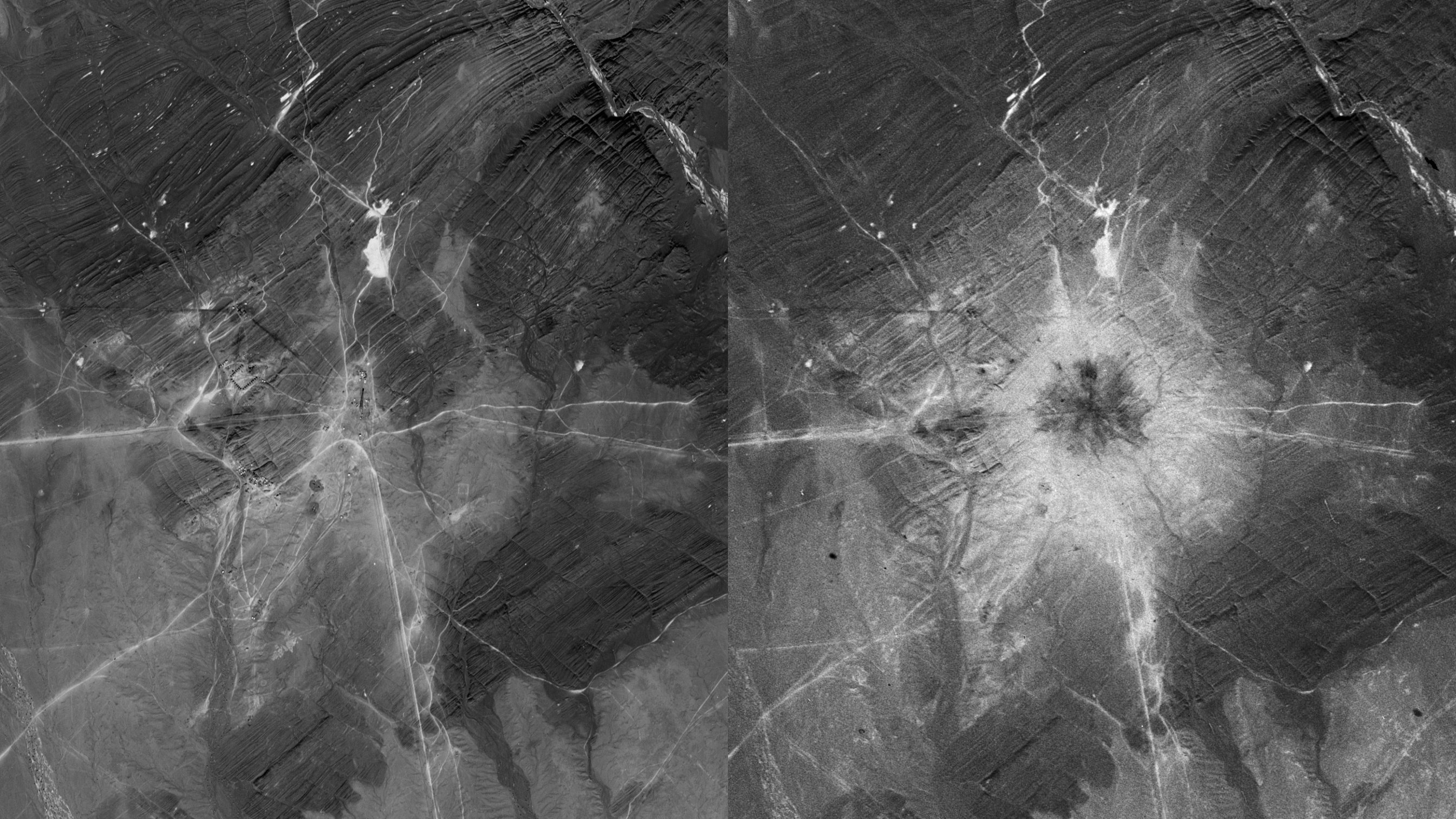
By September 25, 1964, a KH-7 GAMBIT pass photographed Lop Nur 21 days before China’s first test. In August that year, an NRO-derived Special National Intelligence Estimate had concluded that a Chinese nuclear test could be imminent, based in part on satellite imagery of site preparations. [6] What the September 25 frame shows is a test area in a state of late-stage readiness. The test tower, and more-so the shadow of the tower can be clearly seen in the image.
China detonated its first nuclear device, Project 596, on October 16, 1964. It was mounted on the 102-meter tower seen in the September 25, 1964, image with a yield of 22 kilotons. With the test, China became the fifth nuclear power. [7]
")
Four days after the test, on October 20, 1964, a KH-4A CORONA frame shows the Lop Nur area in the immediate post-test period. Together, the September 25 and October 20 frames present one of the earliest and clearest documented satellite before-and-after records of a nuclear test anywhere.
")
By December 8, 1966, a KH-7 image shows a much upgraded site. Visible in that frame is a large circular feature with radial instrumentation lines extending from a central point, a ground zero marker of the type used at nuclear test sites to calibrate blast effects at known distances. A test followed on 28 December 1966. [4] By this point China had conducted five tests, and the Lop Nur infrastructure had expanded substantially from the bare desert of the 1961 KH-3 frame.
The sequence in the archive, from 1961 through 1967, documents a test program across its most critical early phase. And yet, that was only the beginning of nuclear testing at Lop Nur.
Semipalatinsk Test Site, Kazakhstan
Location: Northeastern Kazakhstan
Total tests: 456
The Semipalatinsk Test Site was the Soviet Union’s primary continental nuclear testing ground and the site of more nuclear detonations than anywhere else on Earth.
Construction began in 1947 on the eastern Kazakh steppe. On August 29, 1949, the site hosted RDS-1, the Soviet Union’s first nuclear test, just over four years after the U.S. conducted the Trinity test. The device yielded 22 kilotons and ended the American nuclear monopoly four years earlier than Western intelligence had estimated. [9]
By the 1960s, CORONA and GAMBIT were capturing regular coverage of the site with craters, test towers, tunnel entrances, instrumentation infrastructure, and the expansion of the closed administrative city of Semipalatinsk-21 (later renamed Kurchatov). [10]

KH-4A CORONA imagery of the Semipalatinsk Test Site from September 15, 1964 is in the declassified archive, covering the site including Chagan Lake, a crater lake formed by a 1965 nuclear test that was later used as a reservoir. A higher resolution KH-7 image from May 30, 1965 provides a closer look at the site with targets, craters and more visible. A further KH-4A pass from June 28, 1968 provides a later look at the expanded site.
")
Between 1949 and 1989, Semipalatinsk hosted 456 nuclear detonations, including 116 atmospheric tests before the 1963 Partial Test Ban Treaty moved testing underground. [11] The site was closed on August 29, 1991, exactly 42 years after the first test.
Novaya Zemlya, Russia
Location: Arctic Ocean, northwest Russia
Total tests: 130
Novaya Zemlya is an archipelago in the Barents Sea, designated as a Soviet nuclear test site in July 1954. The first test, an underwater explosion, was conducted on September 21, 1955. [12] Its remoteness and geography made it the preferred site for the Soviet Union’s largest and most powerful tests, including the most significant detonation in human history.
 Tsar Bomba test site in Zone C of Novaya Zemlya, Russia, July 7, 1961.")
On October 30, 1961, the Soviet Union detonated the Tsar Bomba at Zone C on the northern island. At 50 megatons of TNT equivalent, it remains the most powerful nuclear weapon ever detonated. [13] The fireball reached a diameter of approximately 8 kilometres. The shockwave circled the Earth three times. The detonation occurred via air drop, and the Tu-95 aircraft delivering the weapon had to be 39 kilometres away at the moment of detonation to have any chance of survival.
CORONA satellites were operational before the Tsar Bomba test and continued photographing Novaya Zemlya throughout the 1960s. The remoteness of the site, well above 70 degrees north latitude, posed collection challenges, such as heavy cloud cover, but the archipelago’s scale and the distinctive geography of its test zones were identifiable from orbit. Zone B at Matochkin Shar, used for underground testing from 1964 onwards, is visible in declassified frames from this period.
")
Between 1955 and 1990, Novaya Zemlya hosted 130 nuclear detonations with a total explosive energy equivalent to 265 megatons of TNT, more than all the explosives used in the entirety of World War II, including the atomic bombs dropped on Hiroshima and Nagasaki, multiplied more than a hundred times over. [13]
Maralinga, South Australia
Location: Great Victoria Desert, South Australia
Total major tests (Australian sites): 12
The satellite imagery of South Australia in the declassified archive is global orbital coverage rather than targeted surveillance. What it documents is nonetheless significant: the physical footprint of nuclear weapons testing on Australian soil, and its lasting mark on the landscape.
Britain conducted 12 major nuclear tests in Australia between 1952 and 1957, across three sites within the Woomera Prohibited Area: the Montebello Islands off the Western Australian coast, Emu Field in the South Australian desert, and Maralinga. [15] We’ll be focusing on Maralinga here.
Maralinga was a permanent test site was established within the Woomera Prohibited Area in 1955. Between 1956 and 1963, Britain conducted seven major nuclear tests at Maralinga across two main series: Operation Buffalo (four tests in September & October 1956) and Operation Antler (three tests in September & October 1957). The largest single test at Maralinga was the Taranaki shot on 9 October 1957, a balloon-suspended device that yielded 26.6 kilotons. [16]
However, the seven major tests are not what left Maralinga most contaminated. Alongside the main detonations, approximately 550 minor trials were conducted between 1953 and 1963, tests of nuclear weapons components, initiators, and the effects of fire and conventional explosions on warhead assemblies, all involving fissile materials without nuclear yield. The Vixen B trials alone dispersed around 22 kilograms of plutonium-239 across the site. [17] With a half-life of over 24,000 years, that plutonium is, in any practical sense, quite permanent.
")
The frames covering Maralinga are in the SpaceFromSpace archive, all from the post-testing period.
The earliest and most historically significant is the KH-4A CORONA frame from October 10, 1965, two years after the last minor trial, and two years before the first cleanup attempt of 1967. With no remediation underway and the site on caretaker status, the 1965 frame shows Maralinga as it was left: the grid of test firing bays, permanent site buildings, and both minor and major test areas visible. Unlike the Soviet and Chinese sites where analysts were looking for pre-test preparations and post-shot changes, this is something different, a show of abandonment.
A KH-9 HEXAGON frame from November 6, 1972 provides a second (partially cloudy) look, seven years after the first. By 1972 the initial 1967 cleanup had come and gone, declared adequate, and subsequently found to be inadequate. The test site remained contaminated and restricted. Little would have visibly changed between the 1965 and 1972 frames. The significance is the gap itself.
Nevada Test Site, USA
Location: Nye County, Nevada, 65 miles northwest of Las Vegas
Total tests: 928
The Nevada Test Site is the only site on this list that is on American soil. The archive currently holds KH-7 frames of Nevada, which are almost certainly a product of calibration and reference collection rather than surveillance as analysts needed to know exactly what a nuclear test site looked like from KH-7 altitude against a site whose infrastructure, craters, and ground disturbance patterns were already completely understood. That knowledge transferred directly to interpreting Lop Nur, Semipalatinsk, and other sites.
")
The site was established in December 1950 and opened with its first test Shot Able, a 1-kiloton device dropped from a B-50 bomber over Frenchman Flat on January 27, 1951. [18] Between 1951 and 1992, the United States conducted 928 nuclear tests here. One hundred were atmospheric, conducted above ground until July 1962. 828 were underground, beginning with Operation Nougat in 1961 and ending with the final test, Divider, on September 23, 1992. [18]
")
By the time KH-7 became operational in July 1963, atmospheric testing at NTS was already over, with the Limited Test Ban Treaty ending it in August 1963. What the two KH-7 frames in the archive show is the underground testing era. A surface defined by crater fields, instrumentation roads, and the distinctive scarring of Yucca Flat, where the majority of the underground shots took place. The craters are subsidence features, the ground collapsing into cavities left by underground detonations, and at NTS they cover Yucca Flat in a pattern dense enough to be read from orbit as unambiguously industrial. The same signature, seen at lower resolution over Semipalatinsk or Lop Nur, told analysts precisely what they were looking at.
928 tests. 3,561 square kilometers. The site has been called, with some justification, the most bombed place on Earth.
Other Test Sites
Moruroa, an atoll in French Polynesia was reportedly home to somewhere between 175 and 181 nuclear tests between 1966 and 1995. A KH-7 GAMBIT imaged the site on May 26, 1967.
CEMO, In Ekker, French Algeria, was home to 13 underground tests and 5 surface tests between 1961 and 1966. A KH-4B CORONA image taken on November 8, 1968, shows the mountainous facility where the underground tests took place.
Access the Imagery
All scenes referenced in this post are freely accessible in the SpaceFromSpace declassified archive. The SpaceFromSpace archive makes images available in an easy to view and share format, as well as indexing these scenes geographically with date and satellite metadata.

Sources
[1] National Geospatial-Intelligence Agency, “The CORONA Program.” NGA.mil. https://www.nga.mil/defining-moments/CORONA_Program.html
[2] NASA / USGS, “CORONA Satellite Photography.” Data.gov catalog entry, last modified March 2025. https://catalog.data.gov/dataset/corona-satellite-photography
[3] Wikipedia, “KH-7 Gambit,” citing NRO summary report and Executive Order 12951 (2002 declassification). https://en.wikipedia.org/wiki/KH-7_Gambit
[4] Richelson, Jeffrey T. (ed.), “Eyes on the Bomb: U-2, CORONA, and KH-7 Imagery of Foreign Nuclear Installations.” National Security Archive Electronic Briefing Book No. 186, 28 March 2006. https://nsarchive2.gwu.edu/NSAEBB/NSAEBB186/
[5] Atomic Photographers Guild, “Project 596 Lop Nur.” https://atomicphotographers.com/atomic-sites/project-596-lop-nur/
[6] National Security Archive, “China’s First Nuclear Test 1964 — 50th Anniversary.” Briefing Book, 16 October 2014. https://nsarchive.gwu.edu/briefing-book/nuclear-vault/2014-10-16/chinas-first-nuclear-test-1964-50th-anniversary
[7] Wikipedia, “Project 596,” citing Lewis, J.W. & Xue, L., China Builds the Bomb (Stanford University Press, 1988). https://en.wikipedia.org/wiki/Project_596
[9] Wikipedia, “RDS-1.” https://en.wikipedia.org/wiki/RDS-1
[10] Wikipedia, “Semipalatinsk Test Site.” https://en.wikipedia.org/wiki/Semipalatinsk_Test_Site
[11] Hibakusha Worldwide, “Novaya Zemlya.” https://hibakusha-worldwide.org/en/locations/novaya-zemlya
[12] Nuclear Threat Initiative, “Central Test Site of Russia on Novaya Zemlya.” https://www.nti.org/education-center/facilities/central-test-site-of-russia-on-novaya-zemlya/
[13] Wikipedia, “Novaya Zemlya.” https://en.wikipedia.org/wiki/Novaya_Zemlya
[15] Wikipedia, “Nuclear weapons tests in Australia.” https://en.wikipedia.org/wiki/Nuclear_weapons_tests_in_Australia
[16] Tynan, Elizabeth. “This black smoke rolling through the mulga: almost 70 years on, it’s time to remember the atomic tests at Emu Field.” The Conversation, 19 March 2022. https://theconversation.com/this-black-smoke-rolling-through-the-mulga-almost-70-years-on-its-time-to-remember-the-atomic-tests-at-emu-field-181061
[17] Wikipedia, “British nuclear tests at Maralinga.” https://en.wikipedia.org/wiki/British_nuclear_tests_at_Maralinga
[18] Nevada National Security Site, “Our History.” https://nnss.gov/about-the-nnss/nnss-history/