Soon after World War II, the United States military began studying the military uses of space. A 1946 report produced by an aerospace contractor identified reconnaissance as a primary mission for a satellite, studying the possibility of using a television camera to photograph targets on the ground and relay them to a ground station. Over the next decade, the U.S. Air Force continued sponsoring studies of satellite reconnaissance, and in 1956 the service formally began development of a reconnaissance satellite. However, the project was underfunded and did not make much progress until the October 1957 Soviet launch of Sputnik resulted in a dramatic infusion of money and urgency into the program.
The early U.S. satellite reconnaissance program revolved around the use of a technology that exposed film in orbit, developed it, and then scanned it for transmission to the ground. This approach would have enabled the return of only a few dozen images per day, nowhere near enough to cover the vast territory of the Soviet Union. A couple of reconnaissance experts named Amrom Katz and Merton Davies had proposed an alternative approach that would expose large amounts of film in orbit and then return the film to the ground in a small reentry vehicle. By early 1958 their proposal was accepted and given high priority. It was code-named CORONA (reportedly named after the Smith-Corona typewriter used by the people drafting the plans).

The first CORONA system used a panoramic camera that swept a lens over a long, thin piece of film, exposing a large amount of territory in each sweep. Test launches began in early 1959 from a military base on the California coast. The location was selected because rockets could be launched to the south over the Pacific Ocean and enter polar orbit, which enabled a satellite to circle the Earth while the planet rotated below it, eventually covering the entire globe. CORONA suffered from a string of failures throughout 1959 and into 1960, each failure due to a different cause. Finally, in August 1960, a CORONA reentry vehicle successfully returned its film to Earth where it was developed and examined, revealing many new targets and sites of interest within the Soviet Union.

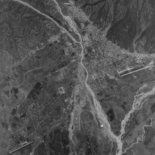
The early CORONA images were not very high resolution, but they covered a tremendous amount of territory. Over the next several years, the imagery improved and the reliability of the system increased. Eventually a second camera was added to the CORONA satellite vehicle, with one camera pointing forward along the ground track and the other pointing aft. This configuration produced photos of objects on the ground at two different angles and made it possible to take more accurate measurements of them. By the end of the program, the cameras were photographing objects on the ground as small as six feet (two meters), which was sufficient to identify most weapons systems.

The Air Force launched CORONA satellites approximately once a month throughout much of the 1960s, and the satellite lifetime increased from one day to over two weeks by the end of the program, and the number of reentry vehicles was increased to two. (Different models were designated KH-1, 2, 3, 4, 4A and 4B.) The satellites collected a tremendous amount of imagery, making it possible to count every bomber, every submarine and ship, and every missile silo in the Soviet Union. CORONA was retired in 1972, replaced by a new system named HEXAGON.
GAMBIT
Although CORONA was very useful for spotting targets and large vehicles in the Soviet Union, its photos were not sufficiently detailed for determining technical characteristics about what they showed. In 1963 the U.S. Air Force launched the first of the GAMBIT satellites. GAMBIT had significantly higher resolution than CORONA, but photographed a much smaller area. A GAMBIT photo could enable an interpreter to take accurate measurements of an object, like a ballistic missile, which could be used to calculate how much fuel it carried and provide an estimate of its range. This information was combined with other data to produce more accurate estimates of a weapon’s performance.

The first GAMBIT satellites were given the designation KH-7, and they were launched multiple times a year, pointed at specific targets of interest identified in CORONA photography. By 1966, an upgraded GAMBIT satellite entered service, designated the KH-8 (as well as the GAMBIT-3). This satellite produced higher resolution photos, but imagery from these later satellites has not been released.

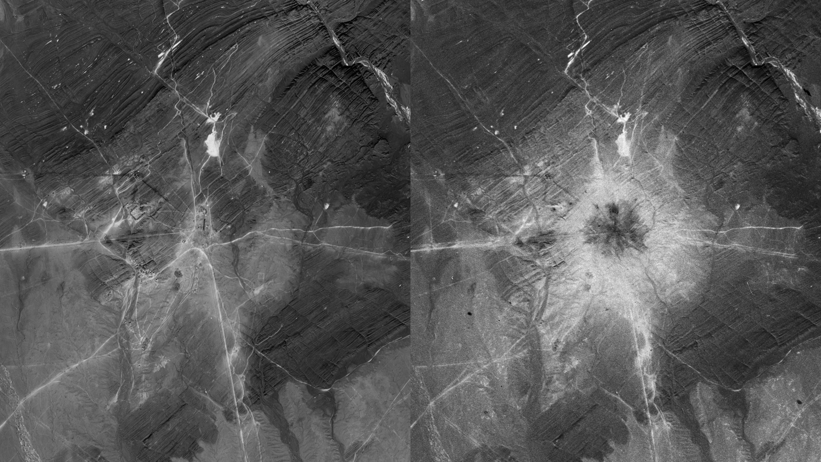
GAMBIT satellites also used film, and they could photograph up to 15,000 targets during a mission. GAMBIT launches continued at a lower rate until 1984. GAMBIT photos in the 1970s into the 1980s were incredibly detailed, able to spot an object on the ground as small as a baseball. They could be used to identify the specific type of missiles being loaded onto airplanes, or differentiate between two types of armored vehicles.
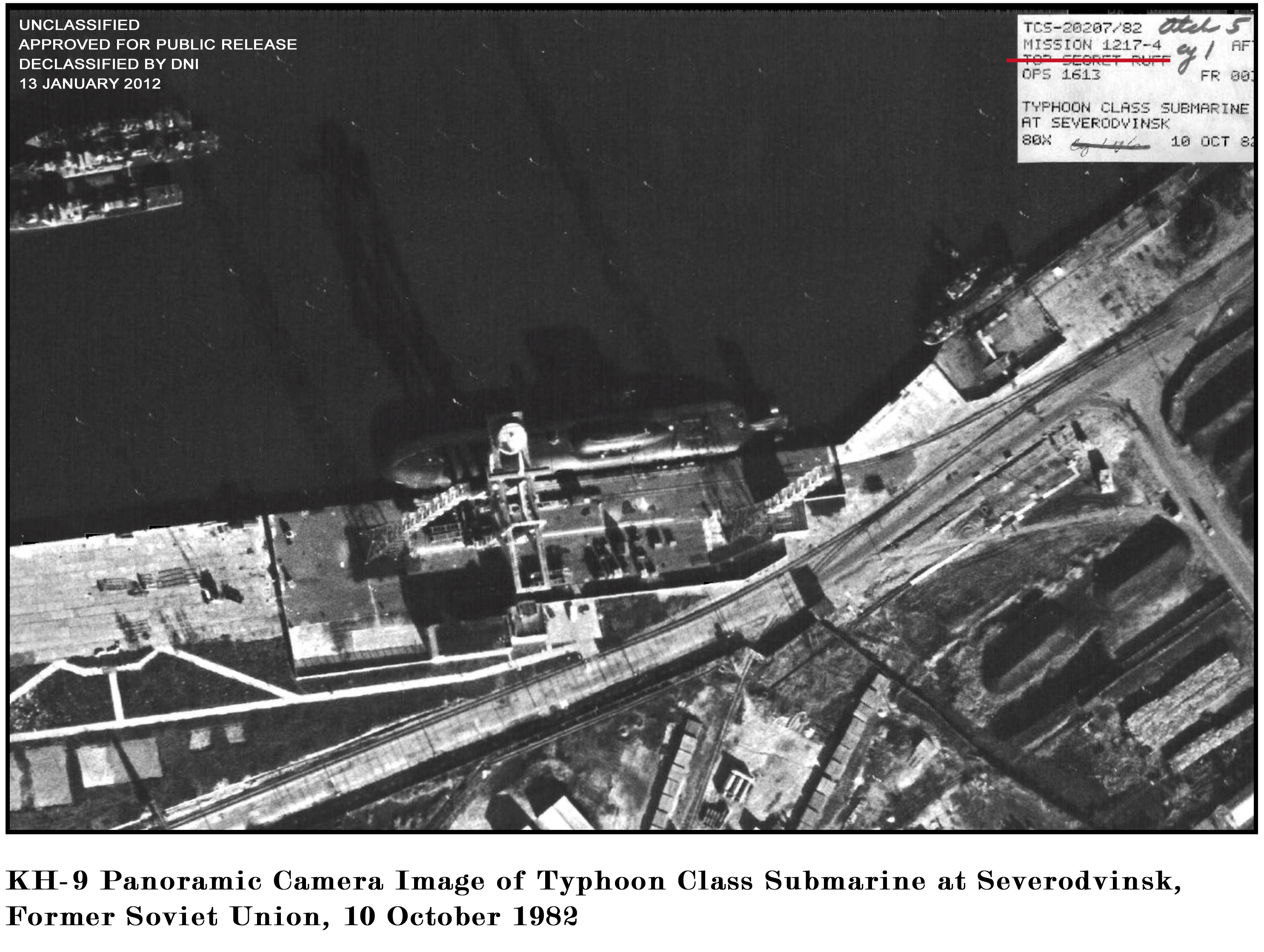
HEXAGON
HEXAGON had been started in the mid-1960s with the goal of photographing huge amounts of territory at significantly higher resolution than CORONA, on the order of 1-3 feet (30 cm – 1 meter). HEXAGON (also designated KH-9) was a big satellite, the size of a school bus. The first HEXAGON was launched in 1971, and the early plan was to launch approximately three per year. After several years, the launch rate was reduced to one per year, and the satellite lifetime increased substantially. Twenty HEXAGONs were launched until 1986 when the twentieth and last one exploded above its launch pad, showering burning debris, and huge rolls of film, on the ground below.

HEXAGON was a marvel of engineering, photographing massive amounts of territory at medium resolution. The imagery was sufficient to identify different types of aircraft and even ground vehicles. Like CORONA, HEXAGON also used film, which was returned to Earth in four reentry vehicles. HEXAGON made it possible to photograph multiple targets such as airfields in a single pass over the Soviet Union, meaning that very accurate counts of weapon systems and deployed forces could be made. But it still took days and often weeks before a photograph taken in orbit over Moscow was looked at by a photo-interpreter in Washington, DC.
KENNEN
In December 1976, the United States launched a new type of reconnaissance satellite designated the KH-11 KENNEN. Unlike CORONA, GAMBIT and HEXAGON, the KENNEN converted its images to digital signals and relayed them through other satellites to a ground station outside of Washington, DC. This meant that a photo taken over the Soviet Union could be seen in Washington within an hour. KENNEN’s images were not as high-powered as GAMBIT, and did not cover as much area as HEXAGON, so those systems remained in use for several more years. But KENNEN’s images were timely, and the satellites did not run out of film and could return images for years until something on the satellite failed. KENNEN became a powerful new intelligence tool.

Very few KENNEN satellite images have been released. Some have been leaked, and those that were officially released have not been identified with a specific type of satellite. At some point in the 1970s or 1980s the satellite was renamed, and very little is known about how it evolved and when (or if) it was finally replaced by a substantially better successor.
The CORONA program was declassified in 1995, and photos taken by those satellites were released at that time. Some GAMBIT imagery was released starting in the early 2000s, but GAMBIT and HEXAGON were not declassified until 2011. These satellites took so many images over decades that very little of it has been viewed by the public.
These satellites were developed and managed by the National Reconnaissance Office, or NRO, a special organization that consisted of components of the U.S. Air Force, Central Intelligence Agency, and U.S. Navy. The NRO was created in 1961, but its existence was classified until 1992. The satellites were built by contractors and launched by the Air Force. The NRO also operated other types of satellites, such as signals intelligence satellites that gathered the emissions of radars and also intercepted communications. But for decades, the photo-reconnaissance satellites like CORONA, GAMBIT, HEXAGON, and KENNEN provided the vast amount of data used by U.S. intelligence agencies and their allies.